


In its account of the deadly fire at CFB Wainwright, the Canadian Armed Forces (CAF) describes an extraordinary chain of events on Oct. 17.
The base, it says, was monitoring a common grass fire that erupted in “uncommonly strong winds,” with flames soon devouring a kilometre in just 30 to 60 seconds.
The military called the event “entirely anomalous.”
A Global News analysis of satellite imagery and weather records, reviewed by seven Canadian wildfire experts, paints a different picture.
As soldiers continued their training on that day, satellites showed the fire had already spread. But the day before, Environment Canada forecast a cold front bringing powerful winds and later issued wind warnings for the area.
And experts say the flames were unlikely to travel at the speed the military suggests, although estimates made during a traumatic event may understandably be imprecise.
More importantly, however, experts say base leadership should have known the dangers posed by the incoming weather, even if they couldn’t predict the precise timing or consequences.
“This was not unexpected given the forecast cold front, the actively spreading fire and the wind warnings that were issued earlier in the day,” says Jen Beverly, an associate professor of wildland fire at the University of Alberta.
According to the military, four soldiers were killed and 39 injured, including 19 critically, when the fire swept through the military training grounds.
It said the fire rapidly intensified and overran soldiers around 4 p.m.
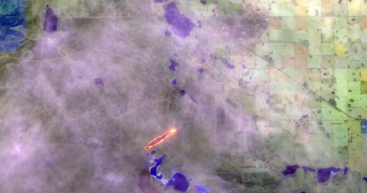
But satellite imagery and weather records show a two-kilometre stretch of fire at noon was likely spreading as winds picked up and a violent cold front approached.
Nearly two weeks after the disaster, crucial questions remain unanswered: What did commanders know about the growing fire and approaching weather? What warnings were passed on? And why were soldiers still training nearby?
The military says its Board of Inquiry, which will answer those questions, could take more than a year.
But weather records, satellite observations and decades of wildfire research already offer important clues about how the tragedy unfolded.
Global examined the evidence and had seven leading wildfire experts review its findings, reconstructing the hours before the disaster to better understand what happened — and whether the fire behaved as unexpectedly as the military has suggested.
The reconstruction traces how the fire may have spread throughout the day, what warnings were issued, and how a forecast wind shift changed the danger. It also raises questions about how quickly the flames advanced — and why soldiers remained in their path.
Long before it became a military training ground, CFB Wainwright was known as Buffalo National Park, established in 1909 to help save plains bison from extinction. Dozens of the once-overhunted beasts still graze on the base today as a commemorative herd.
Those vast, open grasslands face powerful winds, with few natural barriers to interrupt them as they sweep across the prairie.
While the precise combination of weather and fire conditions on Oct. 17 may have been exceptional, the area has seen destructive winds before.
Exactly nine years earlier, on Oct. 17, 2017, gusts exceeding 100 kilometres per hour derailed 13 railway cars at a trestle bridge west of town.
Local Wainwright residents told Global News the area is known for being windy, but the day’s gusts were extraordinary.
However, forecasts predicted those winds.
Since the previous morning, Environment Canada had forecast strong winds, with gusts expected to rise from 60 to 80 kilometres per hour by Oct. 17. The forecast also predicted a shift in wind direction, from southwest to west, that afternoon.
Two hours before the soldiers were reportedly overrun, at 2:14 p.m., Environment Canada extended a yellow wind warning to Wainwright, indicating “hazardous” winds, and forecast gusts up to 100 kilometres per hour.
The base has its own weather station to monitor conditions, while CFB Wainwright’s standing orders, which set out safety rules, require Range Control to receive forecasts twice daily, at 6 a.m. and 6 p.m.
But it remains unclear who was monitoring the weather on Oct. 17.
In a tense exchange with a reporter days after the disaster, Maj.-Gen. Wade Rutland, speaking on behalf of the military, repeatedly declined to say whether Wainwright had a meteorologist or wildfire-behaviour expert, citing the ongoing investigation. Environment Canada provides meteorologists at some military bases, but confirmed none was stationed at Wainwright that day, adding that the base instead received remote forecasting support from CFB Gagetown in New Brunswick.
“Uncommonly strong winds caused the fire to spread rapidly and shift direction,” Rutland said on Oct. 18, speaking on behalf of the military.
While much remains unknown about that day, wildfire experts consulted by Global News said the forecasts and warnings should have raised serious concerns, particularly with an established grass fire already burning on the base. The approaching front threatened to intensify the blaze and abruptly change its direction.
“It was a classic setup,” said Mike Flannigan, a wildfire researcher at Thompson Rivers University.
“You don’t want to be out in the field on a day like Saturday.”
A grass fire ignited on the automatic grenade launcher range that Saturday, although the military has declined to say precisely when it began. At the time, the Canadian Wildland Fire Information System categorized the wildfire danger in Wainwright as “extreme.”
The military’s account of the blaze’s timing has changed. The morning after the tragedy, officials put the ignition time at around 4 p.m. Later that day, Rutland told a briefing that the fire started “several hours earlier,” adding that officials believed it was “contained.”
Asked how big the fire had grown, he declined to say: “I wouldn’t say it was small nor large.”
Four days later, military officials provided more detail, saying the fire was burning inside an area known as Permanent Danger Area 2, a restricted section of the base where live ammunition is fired, and unexploded munitions pose a hazard.
This “restricted the firefighters’ ability to conduct direct suppressive operations,” they said.
However, the base’s standing orders explicitly exempt firefighting and emergency vehicles from certain restrictions on entering the area, including the grenade range impact zone, although the danger posed by unexploded munitions could still prevent firefighters from entering.
They also give Range Control authority to halt dangerous training and coordinate emergency responses. Units must also report changes in a fire’s intensity, direction and speed.
The military has declined to say whether those procedures were followed on Oct. 17, citing the ongoing investigation.
Military officials said Range Control and the base’s fire department monitored the blaze while soldiers continued training nearby.
But high above the Alberta prairie, satellites captured images of a fire far larger than a small patch of burning grass as early as noon.
U.S. Earth-observation satellite Landsat 8 showed active fire at 12:17 p.m., stretching roughly two kilometres in length across the grasslands, with scorched ground already visible behind the flames.
Using the co-ordinates of satellite-detected hotspots recorded in NASA’s Fire Information for Resource Management System (FIRMS), Beverly estimates the blaze covered roughly 48 hectares — equivalent to about 50 football stadiums, including their surrounding grounds.
The military did not respond to questions about whether it agreed with that estimate.
“A one hectare fire is getting to be problematic… so imagine 50 of those,” Beverly said.
“I was quite surprised that anybody would have been working within several kilometres of an active fire knowing that a cold front was coming and there were wind warnings.”
And those winds were already gathering strength.
The military has described a fire that suddenly intensified as powerful winds swept through the base, overtaking soldiers around 4 p.m. An internal memo obtained by Global News later attributed the rapid spread to an “unexpected and sudden wind change.”
But satellite and weather records suggest the conditions were deteriorating well before then.
At the base airfield, about 15 kilometres from the fire, sustained winds doubled from 15 to 30 kilometres per hour between 1 p.m. and 2 p.m., according to Environment Canada records.
At 2:49 p.m., the U.S. weather satellite NOAA-20 passed overhead and detected heat beyond the earlier fire locations, suggesting the blaze may have been spreading outward.
Based on satellite hotspot data, Beverly estimates the fire had nearly tripled in size, to about 140 hectares, describing it as a “problem fire growing in size.”
Flannigan agrees, noting low humidity and dry grass: “I’d say it was quite active. By two o’clock that fire was running.”
By 3 p.m., temperatures had climbed above 23 C and humidity had fallen below the temperature – a term in fire science known as “crossover” fire conditions. Within an hour, temperatures plunged more than 10 degrees, according to Environment Canada records.
Then the weather began to turn.
At 3:10 p.m., another U.S. weather satellite, GOES-18, which monitors western North America at 10-minute intervals, recorded about 76 megawatts of fire radiative power — a measure of the energy emitted by the blaze. Twenty minutes later, satellite readings showed the fire’s radiative power had surged almost sixteenfold to 1,215 megawatts — before falling sharply over the next 10 minutes.
The readings indicate a major escalation in fire activity as a cold front reached the training grounds, Flannigan said, about 30 minutes before the military said the fire reached soldiers.
As the cold front swept through, Environment Canada recorded an 82-kilometre-per-hour wind gust at the CFB Wainwright airfield at 3:16 p.m. Temperatures plunged more than 10 degrees within the hour.
Beverly described the sudden change in fire behaviour as a textbook example of what happens when a cold front moves across an established blaze.
“This is a well-known pattern,” she said, adding that she teaches it to the students in her undergraduate course.
For soldiers caught in its path, the speed and intensity of the flames could have left little time to escape.
Both the military and Prime Minister Mark Carney have described the fire travelling roughly a kilometre in under a minute, from where it had been burning on the training grounds to soldiers conducting exercises.
Rutland put the time at 30 to 60 seconds, citing a commander on the ground — equivalent to 60 to 120 kilometres per hour if the flames travelled the full distance. However, he acknowledged the fire may have already spread unseen through the terrain, something the investigation would seek to establish.
Three wildfire experts cautioned that estimates made in the chaos of a rapidly advancing fire, particularly one involving serious injuries and loss of life, may understandably be imprecise.
But they also said the reported speed would be extraordinary.
Marty Alexander, one of Canada’s most experienced wildfire researchers, developed a widely used rule of thumb suggesting spread rates of roughly 20 per cent of sustained wind speed under critical burning conditions. His research documented a fire in New South Wales, Australia, that spread at 27 kilometres per hour — the fastest he was aware of.
“A grass fire rate of spread of more than 60 kilometres per hour is very highly improbable,” he told Global.
Researcher Cordy Tymstra said the fastest documented Canadian grass fire he knew of, a fire in Granum, southern Alberta in 1997, averaged 14.7 to 16.8 kilometres per hour — far below the military’s Wainwright estimate.
However, three experts Global spoke to said spotting could have driven the rapid spread, as wind-blown embers ignite new fires ahead of the main blaze.
But they also said whether the fire travelled a kilometre in one minute or several, soldiers caught in its path would have had little chance of escape.
The greater danger, they said, was the forecast wind shift, which could turn the long flank of an established fire into a rapidly advancing front, sending flames racing in a different direction.
All the experts whom Global consulted said it was well understood that a wind shift can intensify an established fire.
“If a two-kilometre fire turns into a two-kilometre fire front, you can’t go sideways,” says Flannigan.
“You can only go directly away from it. But given the speed it was travelling and the terrain, most people couldn’t outrun it.”
The base’s standing orders identify August through October as a high-risk fire period and advise units to plan live-fire exercises in the early morning, when fire danger is generally lower.
The orders also prohibit tracer ammunition, pyrotechnics and white phosphorus during extreme fire danger, but do not specifically list automatic grenade launchers or high-explosive grenades in those fire-hazard restrictions.
Asked about the orders, Rutland described them as a “guideline,” saying commanders must assess multiple factors before deciding whether to proceed with shooting and that soldiers train in all conditions.
It’s commonly known that fires are a recurring hazard at CFB Wainwright, as they are at military bases where live ammunition can ignite dry vegetation. The military also conducts controlled fires in spring to reduce the grass and other material that could fuel future outbreaks. But these too can escape in strong winds.
A 2026 scientific study, in collaboration with the Department of National Defence (DND) and CFB Wainwright, examined an April 2024 prescribed burn at Wainwright that escaped its intended boundaries under strong winds and eventually burned approximately 600 hectares.
In 2017, another military grass fire at CFB Suffield burned approximately 36,000 hectares during strong winds, prompting the military to pledge improvements to its fire-prevention procedures.
It found that half of hazardous incidents at the sites examined had not been investigated and warned that safety risks could be accepted without appropriate authorization or senior management awareness.
The audit did not establish whether those failures occurred specifically at Wainwright.
But two weeks after the disaster, lingering questions remain.
DND did confirm, however, that it has made no changes to safety measures since the tragedy and that its Board of Inquiry has yet to be formally convened, although it expects that to happen “in the near future.”
Other agencies have also been reluctant to release information. Environment Canada initially declined to confirm the timing of weather warnings and recorded wind gusts in response to media questions, but later answered after repeated questions.
Wildfire researchers say the tragedy should prompt a closer examination of how the military assesses fire risks, communicates warnings and trains personnel to respond to changing conditions.
“From a fire science perspective it was predictable, and there should have been information flows and procedures in place to ensure that the fire behaviour was understood by those interacting with fire or working near fire on the base,” said Beverly.
Rutland has said the military’s investigation will be made public, with changes to follow where necessary.
“Where they find our procedures, our training, our equipment, or our policies must change, they will change,” he said.