Canadians have been experiencing a “wild” winter, from temperatures in the mid-teens in parts of the country around the new year, to deep freezes as recent as Thursday in southern Ontario. It’s safe to say people are hoping for a calmer spring.
And while the mild temperatures we’ve been frequently seeing will continue into next season, Global News chief meteorologist Anthony Farnell says residents will see “a lot of ups and downs.”
“When it’s warmer than normal, like it has been, we’re going to get the buds and the flowers coming out early,” Farnell said. “Then all it takes is some cold temperatures in April, for things to really go haywire.“
Those “ups and downs” come from the transition the country will be seeing from the El Niño seen this winter, which saw warmer-than-normal water affecting the jet stream and winter patterns, weakening and changing into a La Niña weather system by this summer, bringing cooler-than-normal waters.
But looking at this season, March is expected to start off with extremes, with relatively cold temperatures being seen out west and surprising warmth in the east.
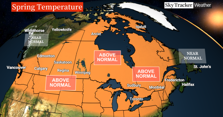
British Columbia will see above-normal temperatures in southern parts of the province, while the north will sit at near normal heat. Precipitation in this province, though, will be near normal in the southern areas, while northern parts can expect below-normal rain or snowfall.
The email you need for the day’s
top news stories from Canada and around the world.
Farnell cautions that with the transition to dry and warm temperatures, there is a chance for another active fire season this year.
If you’re in the Prairies, it’s going to be a fairly mild spring with above-normal temperatures stretching across the region except for northwest Alberta, where it’s more normal heat, though some snowstorms this month are likely.
“That’s good news for the farmers, good news for those areas that are still under rather severe drought; we need to replenish the water tables,” Farnell said, though a dry-out is expected later in the spring.
Average to below-average precipitation is likely to be seen in the Prairies, especially in April and May.
After fluctuating temperatures in Ontario and Quebec had many changing up outfits, the provinces will still see above-normal temperatures through the season.
Farnell cautions, though, that after the warmest February on record, a fairly mild March will transition into a possible “late-season freeze up,” noting it’s a big concern into April.
There could even be one or two big snowstorms later this month or even in April.
However, he adds that after that potential freeze, the weather will turn mild again and could even see an early start to summer.
Since the beginning of 2024, Atlantic Canada has faced snowstorm after snowstorm followed by flooding, and may still have some time to wait before things calm down.
The region will likely see more rain, but also a potential for snow later into March. Cold Atlantic waters will likely lead to a calmer late April and May. Much of the region will still see near-normal temperatures, though, with some above-normal precipitation at times.
Whether it’s La Niña or El Niño, the North — Northwest Territories, Yukon and Nunavut — seems to be “mild and rather extreme up there.”
With Canada heading back into La Niña, Farnell said after the wildfire season seen last year he doesn’t expect the same level but it could still depend on the next couple of months.
And while it won’t take place during the spring, those La Niña conditions could also intensify this summer, bringing a very active hurricane season in the Atlantic, meaning the wild weather that began in winter could continue well throughout the year.
© 2024 Global News, a division of Corus Entertainment Inc.


